|
|
|
|
The helical coordinate |
Jon Claerbout
For many years, it has been true that our most powerful signal-analysis techniques are in one-dimensional space, while our most important applications are in multidimensional space. The helical coordinate system makes a giant step toward overcoming this difficulty.
Many geophysical map estimation applications appear to be multidimensional,
but in reality they are one-dimensional.
To see the tip of the iceberg, consider this example:
On a 2-dimensional Cartesian mesh, the function
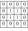
has the autocorrelation
 .
.
Likewise, on a 1-dimensional cartesian mesh,
the function
![]()
has the autocorrelation
![]() .
.
Observe the numbers in the 1-dimensional world are identical with the numbers in the 2-dimensional world. This correspondence is no accident.